


Our Main Office
Construction Equipment Guide
470 Maryland Drive
Fort Washington, PA 19034
800-523-2200
Tue July 25, 2006 - Northeast Edition


(Editor's Note: This article is the third in an occasional series on iconic United States construction projects.)
"Hi there, neighbor, going my way? East or West on the Lincoln Highway?" — Song introducing The Lincoln Highway radio broadcasts in 1940.
Bypassed by today's interstates, segments of the old Lincoln Highway, America's first coast-to-coast road, still remain, nostalgic reminders of the time when people had the time of their lives driving.
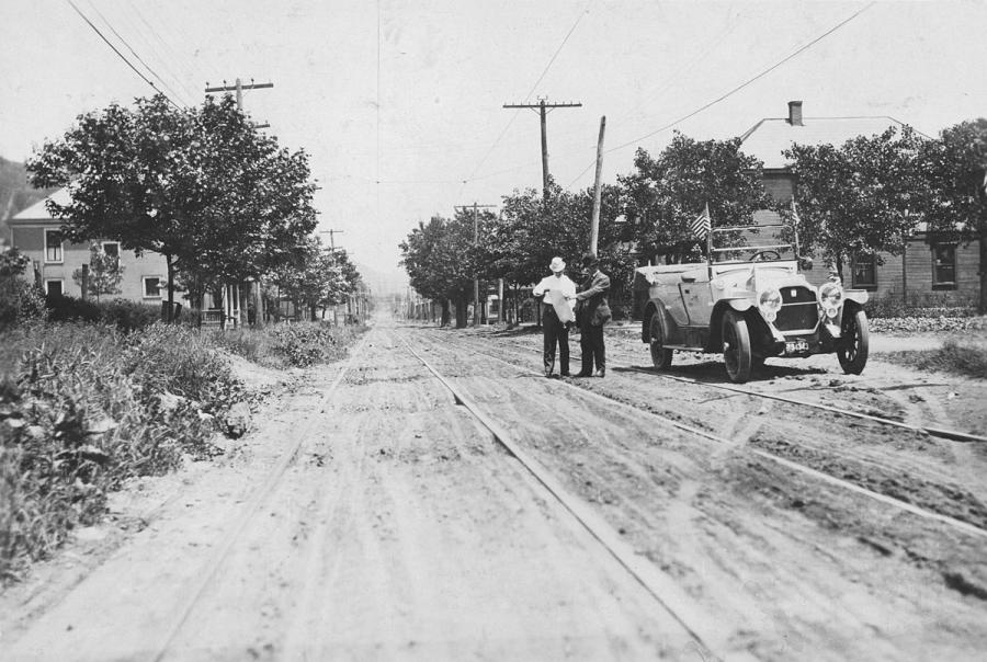
The Lincoln Highway, begun in 1913, was an adventure. Motorist would drive their Model T, Packard Touring Car, or other auto, with a smile (if the motor and tires behaved), and a camaraderie among passengers that participants never forgot.
Drivers followed red-white-and-blue markings painted on telephone poles, garage doors, hotel signboards, or stakes in the desert. In the West, they sometimes had to open and close gates and then ride through ranches.
Directions included such items as "pass in front of saloon buildings and turn to left around shearing pens" or (in Western Wyoming) "Four corners, turn R, still follow phone poles, pass general store on L."
Built when highways had names instead of numbers, and with private rather than government funding, the Lincoln Highway has its own legendary place at the beginning of American roadways.
In 1912, driving fever was sweeping the nation. Only nine years before, in 1903, Horatio Nelson Jackson and Sewall Crocker (and a bulldog named Bud) had completed the first transcontinental auto trip, in an open-top Winton, from San Francisco to New York City in 65 days. Ford Motor Co. was producing its Model T, introduced in 1908, for the common man (despite a few shortcomings such as having to climb hills in reverse because the gas tank under the front seat fed fuel by gravity).
In 1909, 22-year-old Alice Ramsey became the first woman to drive from New York City to San Francisco. She did it in 59 days in a Maxwell 30 touring car. (She had trouble finding a yellow house where directions called for a left turn. Stopping at a farm to inquire, she was told that the owner of the house was "agin'" (against) cars and had repainted it green.)
By 1910, 180,000 cars were registered in the United States.
In those heady days, an entrepreneur-industrialist named Carl Fisher, met with business leaders in Indianapolis, IN, on Sept. 10, 1912, to push his new plan for a "coast-to-coast rock highway."
"Let's build it before we're too old to enjoy it," he said.
Fisher, who had made the Indianapolis Speedway a reality in 1909, and whose properties included the future Miami Beach, proposed that each auto manufacturer, dealer and maker of auto accessories pledge one-third of one percent of its gross receipts for three years, or one-fifth for five years, for the new road. He expected to raise at least $10 million this way to buy materials and to contract with cities and states for the road's construction. It would all be free enterprise funding.
Backers responded positively to the great adventure of crossing America. They also recognized that the road would help sales. Fisher himself had been president of Prest-O-Lite Co., which made compressed gas headlights. Frank Seiberling, president of Goodyear Tire & Rubber Co., pledged $300,000 from Goodyear the day of the meeting. Henry B. Joy, president of Packard Motor Co., pledged $150,000 from his company.
Lehigh Valley Portland Cement Co. offered to contribute at least 1.5 million barrels of cement.
Fisher sold the idea that the new highway could be completed in time for the Panama-Pacific International Exposition in San Francisco in 1915.
The group incorporated as the Lincoln Highway Association (LHA), headquartered in Detroit, MI, on July 1, 1913, with Joy as president. Joy, whose father had known Abraham Lincoln, suggested the new route memorialize the assassinated president "for the good of the people in good roads; let good roads be built in the name of Lincoln."
LHA's board of directors prepared a map, with a red line showing the proposed route across 12 states.
Fisher talked up the plan at the Conference of Governors in August 1913. He had raised $4.2 million, less than half of the amount needed. On the train returning home in September, members of the board drafted a public announcement proclaiming that LHA's aim was "to immediately promote and procure the establishment of a continuous improved highway from the Atlantic to the Pacific, open to all lawful traffic of all descriptions, without toll charges and to be of concrete wherever practical."
President Woodrow Wilson became the first outside member of LHA in September 1913, sending a $5 check to join.
"The idea really picked up steam," said Bob Lichty, president of the association, now headquartered in Canton, OH. "Those initial backers first went to their compatriots in the automotive industry. Almost all the car companies contributed."
Before any new concrete roads were begun, the association mounted a huge, enthusiastic nationwide public relations campaign. It proclaimed Oct. 31, 1913, as a national day of celebration for this memorial highway. Joy made many promotional trips across the country in a Packard touring car.
"Politicians, businesses, and communities got involved, with towns vying against each other to be on the route," Lichty said. "The association even sponsored fund-raisers among school kids, who saved pennies to help build roads. An extremely well-orchestrated and brilliant marketing campaign was behind the whole project."
LHA publicity people even endorsed products, like the Lincoln Highway cigar, distributed 75,000 direct mail pieces, and produced a movie on the highway that was shown at the Pan-Pacific Expo, where Lincoln Highway Day was celebrated with a 365-ft.-long map of the route.
The Lincoln Highway at first was more a route than an actual highway. The first planned route went from New York, NY, to Trenton, NJ, and then west to California through Pennsylvania, Ohio, Indiana, Illinois, Iowa, Nebraska, Wyoming, Utah and Nevada. It was approximately 3,300 mi. long. (A Colorado loop also was included at first, but later dropped. West Virginia was added to the route in 1927.)
Starting from New York City, you took the Weehawken Ferry to New Jersey, went south to Trenton and then west to the Pacific. (Drivers sometimes got their tires wet in the Atlantic Ocean before starting, and got them wet again in the Pacific when they finished.)
The route often paralleled railroad tracks or followed older trails (even those once used by the Pony Express).
Joy and LHA Field Secretary Henry Ostermann both traveled the route many times and performed a good part of the initial mapping, trying for as straight a road as possible. Much of the way was identified with the red, white and blue marks by 1914 and an arrow pointing the way.
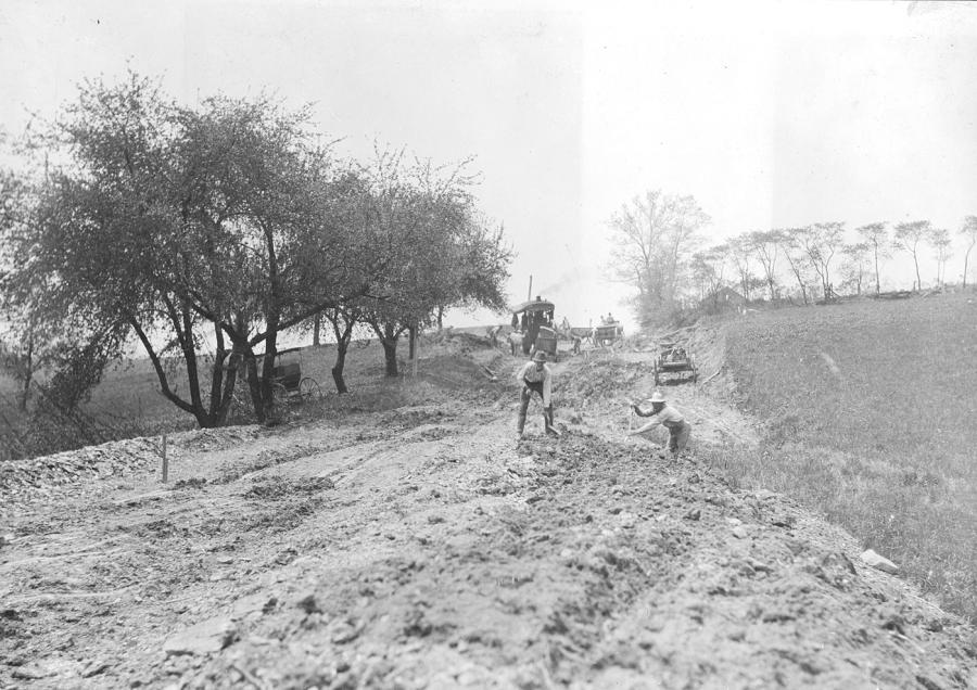
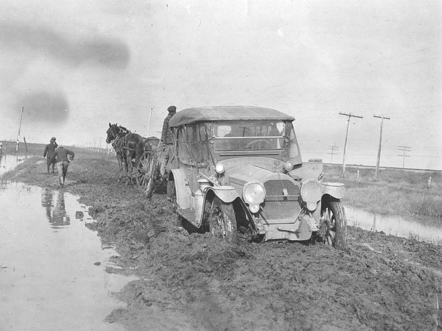
"They plotted the route from east to west, first looking for cities and areas where there were existing roads," Lichty said. "Their whole goal was to build as much road as fast as they could. They started in the East because the cities were closer. Often, not even a mile out of town, you went immediately into gumbo [mud and dirt]."
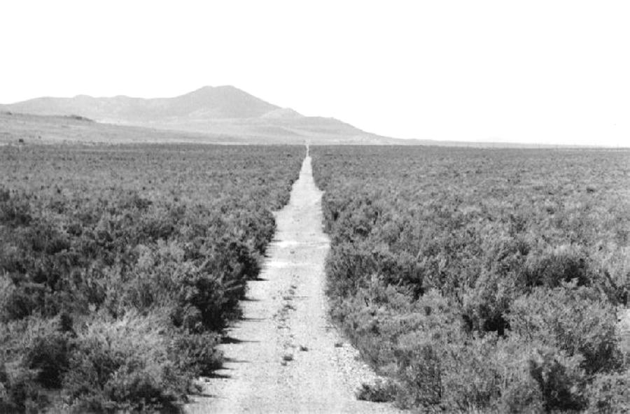
In the West, there were hardly any roads at all, just wagon trails connecting farms to market.
"You traveled by taking down a farmer's fence, throwing it aside, and then putting it back up," Lichty said.
Joy wrote that, on his many trips west, "there were no fences, no fields, nothing but two ruts across the prairie."
Motorists made their way using imprecise guidebooks. A 1913 guide had 18 gates to open and close between Laramie, WY, and Rawling, WY.
One traveler wrote: "Until about 1917, the Lincoln Highway was defined by the towns it passed through more than by the road itself. How a traveler got from town to town, and by which route, was pretty much left up to the imagination."
Wrote Drake Hokanson, in "The Lincoln Highway, Main Street Across America" (University of Iowa Press, 1988): "Everybody knew that this road, like almost every other road in the country, was terrible. Some people called it a red line connecting all the worst mud holes in the country. And to a great extent they were right. West of Pittsburgh [PA] it lacked any resemblance to a connected route. There wasn't a single foot of permanent paving outside of a few towns and cities, and there were but 650 miles of crushed-rock surfacing out of some 3,300 miles of road. In places out West, the new Lincoln Highway grew faint as wheel tracks fanned out across the desert, or disappeared altogether beneath the currents of streams in flood."
Of the 2.5 million mi. of U.S. roads in 1912, less than 7 percent were improved with grading or graveled macadam.
A driver started a car by cranking it up, and got gas in a ladle at a hardware store or blacksmith shop. One motorist in 1912 said he saw only one gas station between New York and San Francisco, and that was in a suburb of Chicago.
And motorists loved the highway for its adventure, from the eerie silence of the prairie to being pulled out of the mud by a farmer who charged double the second time.
In 1913, while most of the route was still unpaved, 150 people crossed the land, leaning against the wind, mostly in open cars.
"Hints to Intercontinental Tourists," written by LHA's chief engineer, advised motorists in 1914 to "carry yellow goggles; don't carry good clothes, ship them," and gave instructions on getting out of mud holes and sleeping on the ground (dig a trench to fit your hips.
LHA's official guidebook, published in 1915, advised: "Don't allow the car to be without food of some sort at any time west of Salt Lake City … Don't wear new shoes."
The association spent most of its money on education, rather than actual roadbuilding, which was often done by local communities.
"The only construction tool it [LHA] ever owned was a grader, which it purchased and loaned to a Utah rancher," wrote Hokanson. "Machinery by our standards was extremely primitive. Initially they used horses but power equipment was developing in the same era. Concreting was very much by hand."
Joy recognized in 1914 that the association wouldn't realize its $10-million goal, or even come close to completing the highway in 1915. He decided that the association would continue to seek donations for construction but would leave the burden of major funding to the state, counties, and communities on the route.
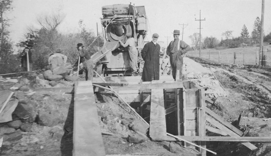
LHA would build a "model road," of poured concrete, from coast to coast, carrying forward concrete technology, which had produced the first rural concrete road in 1908.
The association came up with a brilliant marketing tool called the "Seedling Mile."
Several of these 1-mi. long, hard, wide concrete pavements were laid equidistant between towns in Iowa and Illinois. Portland Cement Co. donated the materials and local people performed the work, so there were no costs for the association, which could then use the stretch to demonstrate how good the concrete Lincoln Highway would be.
The first seedling mile was completed near De Kalb, IL, in the fall of 1914, followed in 1915 by two in Nebraska, one in Illinois, and one in Indiana. By 1919, when the seedling program ended, LHA had spent approximately $1 million on the program in these states, plus Ohio and Iowa. The seedling mile was one of the first concrete sections in Iowa.
In 1921, the association also built a 1.3-mi. long "Ideal Section" in Indiana between Schererville and Dyer on the Illinois-Indiana border. Concrete paving was 10 in. thick and 40 ft. wide to allow four lanes of traffic. Most of the $167,000 project was funded by LHA through a donation from U.S. Rubber Co.; the rest came from state and county funds.
Many sections of the roadway in Ohio and Iowa were at first of brick, using local materials. Many other sections were gravel.
Though the goal of completing the highway by 1915 was not realized, enough roadway was completed by the early 1920s that the Lincoln Highway was America's best-known highway, and was sometimes called "America's Main Street."
"The Lincoln Highway was an immediate success; it opened America to both truck commerce and tourism," Lichty said. "Traffic was so great that garages here in Canton were open 24 hours a day, seven days a week. The road in New Jersey was packed with vehicles in 1915. It looked like a modern-day Phoenix."
In 1919, Henry Osterman, field secretary of LHA, driving a white Packard touring car, led a 2-mi. long convoy of 56 military vehicles and 10 other vehicles (including a small tank), and 297 officers and enlisted men who lurched and bumped 3,310 mi. from near the White House in Washington, D.C., to Lincoln Park in San Francisco.
(In 1920, Osterman traveling with his new bride on his 21st transcontinental trip over the Lincoln, was killed in Iowa when his white Packard, traveling 50 mph, slid across grass and rolled over.)
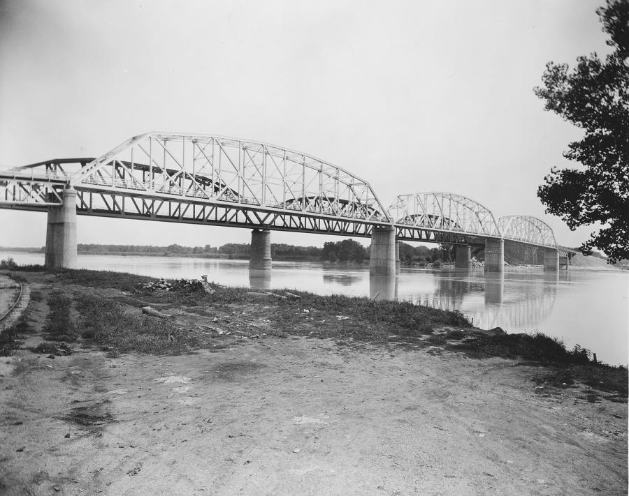
The trip, almost all along the Lincoln Highway, tested how the heavy vehicles could make it to the west coast. It took 60 days. Besides plowing through mud holes, trucks fell through 100 bridges, which Army engineers rebuilt.
Lt. Col. Dwight D. Eisenhower was a last-minute volunteer. He never forgot the lesson. After being elected president, "Ike" was one of the main proponents of the new Interstate Highway System (IHS), signing the Interstate Highway Act of 1956. The Interstate System observed its 50th anniversary this year with a reenactment of the 1919 transcontinental trip.
The original road system of highways with names and their own colors had some big problems.
"Each highway had a different color band; in major cities, a motorist might see three or four bands on a telephone pole and wouldn't have a clue what to do," Lichty said.
In 1925, the Federal Government adopted the present plan of numbered highways, which had been suggested by the American Association of State Highway Officials (AASHTO). East-West roads would be even-numbered while north-south ones would be odd-numbered. Transcontinental highways would bear numbers in multiples of 10.
The Lincoln and other named highways like the Dixie Highway or Jefferson Highway were officially broken into numbered highways. The Lincoln became U.S. 1 from Newark, NJ, to Philadelphia, PA, and then U.S. 30 to Salt Lake City, UT.
Despite the change to numbers, the association was granted permission to mark the old highway with concrete posts as a memorial to President Lincoln.
Approximately 3,000 markers were cast, each with a small directional arrow and a small bronze bust of Lincoln. On Sept. 1, 1928, Boy Scouts across the United States set them into holes approximately 1 mi. apart along the route. Lichty said that day was when the Lincoln Highway was officially dedicated and completed.
LHA was disbanded early in 1928 and revived in 1992.
In 1931, L.B. Miller drove a Plymouth from San Francisco to New York and then back again in five days, 12 hours, and nine minutes. Much of the Lincoln Highway route was now an improved, all-weather, hard-surface highway.
While perhaps 125 motorists crossed the country in 1913, hundreds of thousands did it in 1931, according to the Hokanson book.
The Lincoln Highway, similar to Route 66, entered American folklore. Thirty-minute "Lincoln Highway" Saturday morning radio broadcasts in the early 1940s used the highway as the setting for dramas, with Announcer John McIntire saying: "Yes, this is the road that links the farms, the mines and the mills of America. And there's nothing that hasn't happened at one time or another along its 3,000 miles. The Lincoln Highway!"
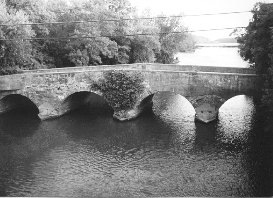
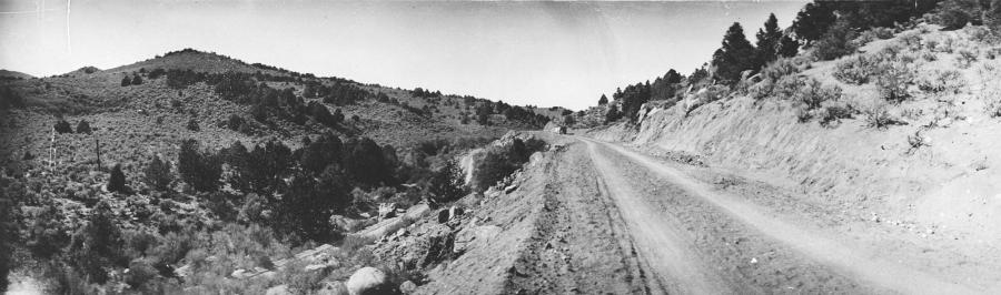
Today, much of the original Lincoln has, of course, been paved over by new roads, realigned, or bypassed. One can still follow much of the old route, though, with the aid of maps and guidebooks.
"I've driven the entire old route," Lichty said. "Some sections are still gravel. They are very well-maintained and easy to drive on."
Menlo Park, NJ, where Thomas Edison invented the incandescent light bulb and phonograph, is just off the highway. The old highway also goes right through Gettysburg, PA, and its Civil War battle sites. The road is now part of their Lincoln Highway Heritage Trail for 140 mi. west from Gettysburg.
Farther west, the highway goes through Dixon, IL, where one can visit the boyhood home of former President Ronald Reagan.
Near Tama, IA, stands one of the road's landmarks, the Lincoln Bridge, built in 1915 with "Lincoln Highway" spelled out in large letters on its two concrete sides. Along the highway in Boone, IA, is the home where "Mamie" Eisenhower, wife of General Eisenhower, was born.
The old route parallels Union Pacific train tracks through part of Nebraska and comes close to Boys Town, founded by Father Flanagan in 1917.
The route starts climbing. At Sherman Summit, WY, it reaches its highest point — 8,825 ft. Farther west, it follows the old wagon road across the Donner Pass.
In some areas, one can just see abandoned traces of the old highway, along a modern road or back in the woods somewhere, nostalgic reminders of the days when the journey was not a destination but an adventure on the road.
Interstate 80, from Teaneck, NJ. to San Francisco, is now the highway that the Lincoln was meant to be. Its four lanes of unbroken, four-lane pavement allow a motorist to travel across the United States in approximately six days.
(Further information is available on www.lincolnhighwayassoc.org. The association is headquartered at 1330 Fulton Rd., NW, Canton, OH, 44703.)
Construction Equipment Guide
470 Maryland Drive
Fort Washington, PA 19034
800-523-2200
Construction Equipment Guide covers the nation with its four regional newspapers, offering construction and industry news and information along with new and used construction equipment for sale from dealers in your area. Now we extend those services and information to the internet. Making it as easy as possible to find the news and equipment that you need and want.
Contents Copyrighted 2024, by Construction Equipment Guide, which is a Registered Trademark, registered in the U.S. Patent Office. Registration number 0957323. All rights reserved, nothing may be reprinted or reproduced (including framing) in whole or part without written permission from the publisher. All editorial material, photographs, drawings, letters, and other material will be treated as unconditionally assigned for publication and copyright purposes and are subject to Construction Equipment Guide’s unrestricted right to edit and comment editorially. Contributor articles do not necessarily reflect the policy or opinions of this publication.
Read our privacy policy here.
Mastodon